

Part of July saw heavy rain in London, and images of flash flooding made the news headlines. According to BBC news, parts of south-west London including Barnes, Raynes Park and Richmond had been affected.
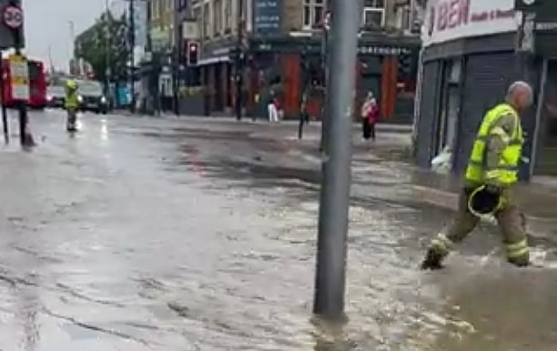
Two weeks later, the flood become suddenly a main concern in Battersea as areas of Clapham Junction were flooded, such as St Johns Road and Falcon Road (both roads covering the Falconbrook stream running underneath, ironically).
The website London Lost Rivers remembers that “in 2007 it burst out of the pavement in several places and flooded the Falcon Road near Clapham Junction station causing havoc in the vicinity.“
That’s the spirit! #MondayMotivation #ClaphamJunction #Flood keep moving – don’t stop pic.twitter.com/FH7ilvdxgM
— D A V I D S A V I Z O N (@DavidSavizon) July 26, 2021
The Wandsworth Guardian reported that around Queenstown Road station the area was completely under-water and roads near Clapham Common were blocked due to floodwater which was “12 to 18 inches deep”. The local newspaper makes a link with global warming, saying:
“Met Office meteorologist Steven Keates said the storms are being caused by a “convergence” of air currents, due to warmth in the earth’s surface from the recent heatwave rising into cooler air in the atmosphere.”
The Council is blaming Thames Water
The leader of Wandsworth Council is blaming Thames Water for the extent of the problem. As reported in local newspaper SWLondoner, he said that said that Thames Water had been aware of the problem for decades and failed to act on it. It is true that in a letter sent to residents in 1998, they acknowledge that they were aware of the problem of “flooding during extreme weather conditions” due to the local sewerage system and where the area is low lying but they were taking measures to remedy. Unfortunately it seems that it is not enough.
Consequences of climate change on most of the areas offered to development in Battersea
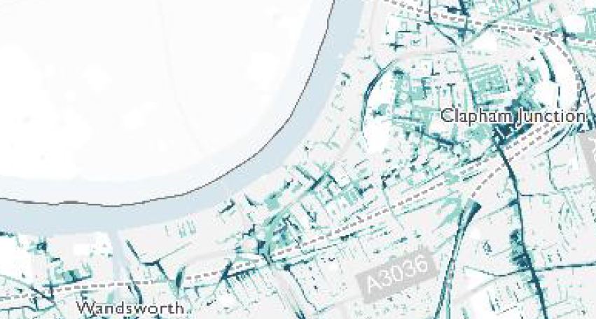
Nevertheless, with global warming, we are meant to see episodes of extreme heat or heavy rain to repeat more often. TimesOut published a map of all the zones at risk and warned that with climate change, rising sea levels and many more areas of London could be underwater within a decade.
Wandsworth has massively built along the river Thames. First Battersea Riverside started 20 years ago, but more recently the whole of York Road area is dedicated to developments and tall buildings. However, an interactive map from Climate Central shows the land projected to be below annual flood level by 2030.

The draft local plan says it has no choice but to build in zones with high risk of flooding
In the draft local plan, Wandsworth set out a series of objectives, but only for 2038 (p22 – 8):
“By 2038 Require development to be fully resilient to the future impacts of climate change, including managing the risks and consequences of flooding.”
It also add (p24) that “development [must be] located away from areas considered to be at high risk of flooding“. Currently it seems that the only restrictions apply regarding basements and improve drainage (Policy LP 12). In the local plan, Zone 3 (Highly risks) and Zone 2 (Medium) are considered the most at risk.
However, the document points out that there is no possibility to accommodate the borough housing target if we don’t use the high flood risk zone (p244):
“15.33 Land within high risk zones accounts for around a quarter of the borough’s area and includes land within the borough’s main investment and growth areas. There are not enough sites within the low flood risk area to accommodate the new housing targets that have been identified for the borough, and therefore it will be necessary to develop in these areas to accommodate growth, which includes the regeneration and enhancement of the borough’s town centres and regeneration sites for a range of uses including significant forecast growth in housing and employment.”
Policy LP12 requires for future development to be considered, to have passed a “Sequential Test”. However, this test is not required for developments located within a Strategic Area, including Clapham Junction and York Road/Winstanley Regeneration Area. More importantly, it says (p244):
“Development which is built during the Local Plan period will be expected to have a life to the end of the century and beyond”
The local plan considers that developments along the river are at residual risk due to the Thames Barrier defence system. Moreover, officers are confident that the modelling used constrains the food risk to very limited circumstances, mostly where development was to encroach into the river (p245, 15.31).
The map 15.2 used in the local plan does not seem to take into account climate change.
As we criticised previously, the draft Local Plan is clearly lacking any substance on its site analysis. It seems that consultants who have been working on it were lacking minimal local knowledge (officers blamed Covid lockdown period, but they never tried to contact local community groups to gather information). For instance, for most of the York area site descriptions, it says to refer to the Lombard Road/York Road Riverside Focal Point
Supplementary Planning Guidance written 7 years ago. In this SPD, the only part referring to flood risk says:
“Flood Risk: The site is located within flood zone 3a. A site specific Flood Risk Assessment is required and should require flow path assessment to confirm residual risks. A flood warning and evacuation plan will be required.”
Within the last 7 years, global warning has become a top priority in every aspect of our lives. However the draft Local Plan is still refereeing to a document drafted before 2015. Is it acceptable?
- Article: Has Wandsworth done a good job in drafting the new Local Plan?
- Download the full submission from CJAG


Flooding, heat and rising sea levels are the problems that should be sorted with climate change.
What do you mean? Planning should not regulate and it should be up to central government to reduced UK impact on climate change? Or Local authorities should include that concern in planning assessment?